Updated 915am CT – Thursday / 30 March 2017
.. Sunshine For the Remainder of the Week ..
.. Another Period of Stormy Weather Over the Weekend ..
.. Sunshine Again Early and Mid Parts of Next Week ..
On this Thursday… a surface low pressure area is located over western Missouri with a cold front extending southward through Arkansas into northern Louisiana then southwestward to off the Texas coast then inland into northeastern Mexico south of Brownsville. High pressure, behind the front, is situated over western Colorado. As a result of this surface weather pattern, our surface winds across south central Texas are west northwesterly.
In the upper levels of the atmosphere, a deep trough of low pressure extends south southwestward from eastern Kansas into Texas. A southeastward moving second trough of low pressure extends southward British Columbia into Washington and Oregon. As a result of this upper air weather pattern, the 30,000 foot winds over south central Texas are southwesterly at 90 to 100 mph.
A dry and stable weather pattern is in place in the wake of last night’s cold front. It looks like plenty of sunshine with above average daytime high temperatures for both today and Friday.
The front, that passes late last night, will come back as it retreats northward as a warm front by tomorrow night with low level moisture increasing once again.
The next upper level low pressure storm system, the one situated over the Pacific northwest, and associated cold front will move southeastward and eastward into Texas and will result in increasing moisture and atmospheric instability and lift by Saturday with increased clouds and renewed and increasing rain and thunderstorm chances by late in the day Saturday into Saturday night and Sunday. I continue to see the chance of periods of heavier rain along with an associated lightning risk and the possibility of severe thunderstorms possibly accompanied by larger hail and damaging straight line thunderstorm winds particularly in the overnight hours Saturday night. Current NWS/Weather Prediction Center guidance indicates that we’ll see 1/2 to 1 1/2 inches of rainfall from this system. Guidance suggests that the system will linger across the area on Sunday with a cold front progressing eastward over our area by afternoon and then it will move east of the area, with decreased rain chances, by late Sunday. Skies will clear by Sunday night into Monday with a dry and stable weather pattern prevailing for Monday and Tuesday.
Another upper air low pressure storm system and associated cold front is slated to move across south central Texas and the IH35 corridor by next Wednesday. Depending on the moisture return into the area ahead of this system, we could see another chance of rain showers and thunderstorms; however, at this point, I don’t have the confidence to mention any precipitation with this wind shift.
Have a good Thursday….
Meteorologist Troy Kimmel
Contact me:
[email protected]
http://www.facebook.com/troykimmel
—
Updated 845am CT.. Thursday / 30 March 2017
TODAY…. Sunshine. High 84. West northwest wind 5 to 12 mph.
TONIGHT…. A clear sky. Low 57. Light wind becoming southerly 4 to 8 mph.
FRIDAY…. Mostly sunny with near record warmth. High 90. South southwesterly wind 8 to 15 mph with some high gusts.
FRIDAY NIGHT…. Mostly clear early then low clouds developing after 12 midnight. Low 64. South southeasterly wind 8 to 15 mph.
SATURDAY…. Morning low clouds.. Partly to mostly cloudy with scattered rain showers and thunderstorms developing, with an attendant lightning risk, by afternoon. A 30% chance of rain by midday increasing to 50% by late afternoon; rainfall, where it occurs, will average 1/4 inch. High 81. Southerly wind 8 to 15 mph.
SATURDAY NIGHT…. Cloudy with numerous rain showers and thunderstorms with an attendant lightning risk. Some thunderstorms may be severe with a hail and straight line thunderstorm wind risk after 9pm. A 50% chance of rain early increasing to 80% by 9pm; rainfall, where it occurs, will average 1/2 to 3/4 inch. Low 64. South southeasterly wind 8 to 15 mph except strong, variable and gusty in thunderstorms.
SUNDAY…. Cloudy with numerous rain showers and thunderstorms with an attendant lightning risk continuing as a cold front passes by mid to late afternoon. Some thunderstorms may be severe with a hail and straight line thunderstorm wind risk through the midday hours. An 80% chance of rain through 3pm with rain chances decreasing afterwards; rainfall, where it occurs, will average an additional 1/4 to 3/4 inch. High 78. Southerly wind 5 to 12 mph becoming southwesterly by early afternoon before shifting north northwest by mid and late afternoon.
SUNDAY NIGHT…. Mostly cloudy with scattered rain showers and thunderstorms with an attendant lightning risk continuing through 8pm A 30% chance of rain; where it occurs, will average an additional 1/4 inch or less. Decreasing clouds after 8pm and a little cooler. Low 57. Northwesterly wind 5 to 12 mph.
MONDAY…. Sunshine. High 81. West northwesterly wind 5 to 12 mph.
MONDAY NIGHT…. A clear sky. Low 57. Light wind.
TUESDAY…. Mostly sunny and a little warmer. High 85. South southeasterly wind increasing to 5 to 12 mph.
TUESDAY NIGHT… A few clouds. Low 62. South southeasterly wind 5 to 12 mph.
WEDNESDAY… Morning low clouds otherwise partly cloudy.
NATIONAL WEATHER SERVICE / 8 TO 14 DAY OUTLOOK
Valid Thursday / 06 April 2017 through Wednesday / 12 April 2017…
Temperature… Above Average
Precipitation… Below Average
AUSTIN SUNSET/SUNRISE TIMES…..
Sunrise this morning (30 Mar)……………………………………………. 7:22 am
Sunset this evening (30 Mar)……………………………………………… 7:49 pm
Sunrise tomorrow (31 Mar)………………………………………………… 7:21 am
Sunset tomorrow (31 Mar)…………………………………………………. 7:49 pm
 URGENT - IMMEDIATE BROADCAST REQUESTED
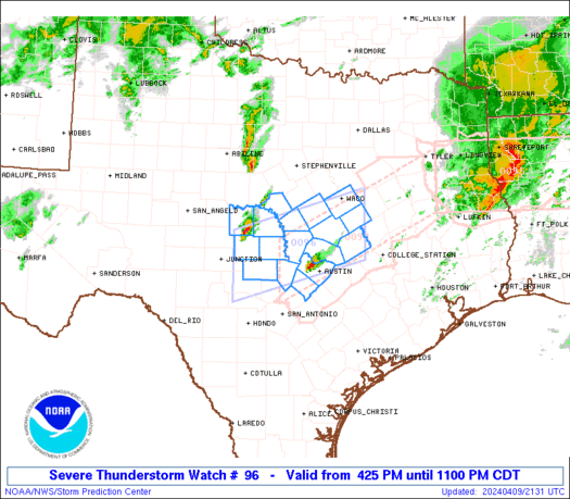
Severe Thunderstorm Watch Number 96
NWS Storm Prediction Center Norman OK
925 PM CDT Tue Mar 28 2017
The NWS Storm Prediction Center has issued a
* Severe Thunderstorm Watch for portions of
Much of north central, central and south central Texas
* Effective this Tuesday night and Wednesday morning from 925 PM
until 400 AM CDT.
* Primary threats include...
Scattered large hail and isolated very large hail events to 2
inches in diameter possible
Scattered damaging wind gusts to 70 mph possible
A tornado or two possible
SUMMARY...Isolated storms may persist for a couple of hours across
the Edwards Plateau, but a squall line moving west-to-east will pose
the primary risk for damaging winds and large hail through the
overnight hours. A tornado or two cannot be ruled out with
circulations embedded in the squall line. The storms may reach the
I-35 corridor, including Dallas-Fort Worth and Austin-San Antonio,
around 2-4 am CDT.
The severe thunderstorm watch area is approximately along and 100
statute miles east and west of a line from 40 miles north of Mineral
Wells TX to 70 miles southeast of Del Rio TX. For a complete
depiction of the watch see the associated watch outline update
(WOUS64 KWNS WOU6).
PRECAUTIONARY/PREPAREDNESS ACTIONS...
REMEMBER...A Severe Thunderstorm Watch means conditions are
favorable for severe thunderstorms in and close to the watch area.
Persons in these areas should be on the lookout for threatening
weather conditions and listen for later statements and possible
warnings. Severe thunderstorms can and occasionally do produce
tornadoes.
&&
OTHER WATCH INFORMATION...CONTINUE...WW 94...WW 95...
AVIATION...A few severe thunderstorms with hail surface and aloft to
2 inches. Extreme turbulence and surface wind gusts to 60 knots. A
few cumulonimbi with maximum tops to 500. Mean storm motion vector
26035.
...Thompson
.OUR LOCAL IH35 CORRIDOR COUNTIES INCLUDED ARE
BELL
BLANCO
BURNET
HAYS
TRAVIS
WILLIAMSON
$$
URGENT - IMMEDIATE BROADCAST REQUESTED
Severe Thunderstorm Watch Number 96
NWS Storm Prediction Center Norman OK
925 PM CDT Tue Mar 28 2017

The NWS Storm Prediction Center has issued a

* Severe Thunderstorm Watch for portions of
  Much of north central, central and south central Texas

* Effective this Tuesday night and Wednesday morning from 925 PM
  until 400 AM CDT.

* Primary threats include...
  Scattered large hail and isolated very large hail events to 2
    inches in diameter possible
  Scattered damaging wind gusts to 70 mph possible
  A tornado or two possible

SUMMARY...Isolated storms may persist for a couple of hours across
the Edwards Plateau, but a squall line moving west-to-east will pose
the primary risk for damaging winds and large hail through the
overnight hours.  A tornado or two cannot be ruled out with
circulations embedded in the squall line.  The storms may reach the
I-35 corridor, including Dallas-Fort Worth and Austin-San Antonio,
around 2-4 am CDT.

The severe thunderstorm watch area is approximately along and 100
statute miles east and west of a line from 40 miles north of Mineral
Wells TX to 70 miles southeast of Del Rio TX. For a complete
depiction of the watch see the associated watch outline update
(WOUS64 KWNS WOU6).

PRECAUTIONARY/PREPAREDNESS ACTIONS...

REMEMBER...A Severe Thunderstorm Watch means conditions are
favorable for severe thunderstorms in and close to the watch area.
Persons in these areas should be on the lookout for threatening
weather conditions and listen for later statements and possible
warnings. Severe thunderstorms can and occasionally do produce
tornadoes.

&&

OTHER WATCH INFORMATION...CONTINUE...WW 94...WW 95...

AVIATION...A few severe thunderstorms with hail surface and aloft to
2 inches. Extreme turbulence and surface wind gusts to 60 knots. A
few cumulonimbi with maximum tops to 500. Mean storm motion vector
26035.

...Thompson

.OUR LOCAL IH35 CORRIDOR COUNTIES INCLUDED ARE

BELL
BLANCO
BURNET
HAYS
TRAVIS
WILLIAMSON
$$