Austin / Travis County and South Central Texas Weather Update #3
Prepared by UT University/Incident Meteorologist Troy Kimmel
935pm CT – Tuesday / 28 March 2017
.. NWS/Storm Prediction Center Issues Severe Thunderstorm Watch Until 4am
for IH35 Corridor Counties Westward ..
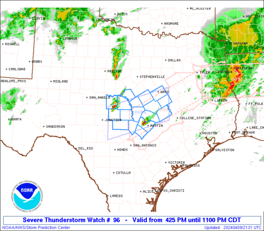
Kimmel Note: Please keep in mind that we’re right on the eastern edge of this watch..
even though it’s possible some discrete cells ahead of the line may affect some areas
(still with a severe risk), it is unlikely that the main line of thunderstorms will affect our
area until after 2am (at least).. keep in mind that, by the time that weather affects our
area and assuming it maintains its intensity, it is likely a new watch will be needed for
the areas along and east of IH35…
Here is where we are in reference to the watch box and details below…
URGENT - IMMEDIATE BROADCAST REQUESTED
Severe Thunderstorm Watch Number 96
NWS Storm Prediction Center Norman OK
925 PM CDT Tue Mar 28 2017

The NWS Storm Prediction Center has issued a

* Severe Thunderstorm Watch for portions of
  Much of north central, central and south central Texas

* Effective this Tuesday night and Wednesday morning from 925 PM
  until 400 AM CDT.

* Primary threats include...
  Scattered large hail and isolated very large hail events to 2
    inches in diameter possible
  Scattered damaging wind gusts to 70 mph possible
  A tornado or two possible

SUMMARY...Isolated storms may persist for a couple of hours across
the Edwards Plateau, but a squall line moving west-to-east will pose
the primary risk for damaging winds and large hail through the
overnight hours.  A tornado or two cannot be ruled out with
circulations embedded in the squall line.  The storms may reach the
I-35 corridor, including Dallas-Fort Worth and Austin-San Antonio,
around 2-4 am CDT.

The severe thunderstorm watch area is approximately along and 100
statute miles east and west of a line from 40 miles north of Mineral
Wells TX to 70 miles southeast of Del Rio TX. For a complete
depiction of the watch see the associated watch outline update
(WOUS64 KWNS WOU6).

PRECAUTIONARY/PREPAREDNESS ACTIONS...

REMEMBER...A Severe Thunderstorm Watch means conditions are
favorable for severe thunderstorms in and close to the watch area.
Persons in these areas should be on the lookout for threatening
weather conditions and listen for later statements and possible
warnings. Severe thunderstorms can and occasionally do produce
tornadoes.

&&

OTHER WATCH INFORMATION...CONTINUE...WW 94...WW 95...

AVIATION...A few severe thunderstorms with hail surface and aloft to
2 inches. Extreme turbulence and surface wind gusts to 60 knots. A
few cumulonimbi with maximum tops to 500. Mean storm motion vector
26035.

...Thompson

.OUR LOCAL IH35 CORRIDOR COUNTIES INCLUDED ARE

BELL
BLANCO
BURNET
HAYS
TRAVIS
WILLIAMSON
$$
 URGENT - IMMEDIATE BROADCAST REQUESTED
Severe Thunderstorm Watch Number 96
NWS Storm Prediction Center Norman OK
925 PM CDT Tue Mar 28 2017
The NWS Storm Prediction Center has issued a
* Severe Thunderstorm Watch for portions of
Much of north central, central and south central Texas
* Effective this Tuesday night and Wednesday morning from 925 PM
until 400 AM CDT.
* Primary threats include...
Scattered large hail and isolated very large hail events to 2
inches in diameter possible
Scattered damaging wind gusts to 70 mph possible
A tornado or two possible
SUMMARY...Isolated storms may persist for a couple of hours across
the Edwards Plateau, but a squall line moving west-to-east will pose
the primary risk for damaging winds and large hail through the
overnight hours. A tornado or two cannot be ruled out with
circulations embedded in the squall line. The storms may reach the
I-35 corridor, including Dallas-Fort Worth and Austin-San Antonio,
around 2-4 am CDT.
The severe thunderstorm watch area is approximately along and 100
statute miles east and west of a line from 40 miles north of Mineral
Wells TX to 70 miles southeast of Del Rio TX. For a complete
depiction of the watch see the associated watch outline update
(WOUS64 KWNS WOU6).
PRECAUTIONARY/PREPAREDNESS ACTIONS...
REMEMBER...A Severe Thunderstorm Watch means conditions are
favorable for severe thunderstorms in and close to the watch area.
Persons in these areas should be on the lookout for threatening
weather conditions and listen for later statements and possible
warnings. Severe thunderstorms can and occasionally do produce
tornadoes.
&&
OTHER WATCH INFORMATION...CONTINUE...WW 94...WW 95...
AVIATION...A few severe thunderstorms with hail surface and aloft to
2 inches. Extreme turbulence and surface wind gusts to 60 knots. A
few cumulonimbi with maximum tops to 500. Mean storm motion vector
26035.
...Thompson
.OUR LOCAL IH35 CORRIDOR COUNTIES INCLUDED ARE
BELL
BLANCO
BURNET
HAYS
TRAVIS
WILLIAMSON
$$
URGENT - IMMEDIATE BROADCAST REQUESTED
Severe Thunderstorm Watch Number 96
NWS Storm Prediction Center Norman OK
925 PM CDT Tue Mar 28 2017
The NWS Storm Prediction Center has issued a
* Severe Thunderstorm Watch for portions of
Much of north central, central and south central Texas
* Effective this Tuesday night and Wednesday morning from 925 PM
until 400 AM CDT.
* Primary threats include...
Scattered large hail and isolated very large hail events to 2
inches in diameter possible
Scattered damaging wind gusts to 70 mph possible
A tornado or two possible
SUMMARY...Isolated storms may persist for a couple of hours across
the Edwards Plateau, but a squall line moving west-to-east will pose
the primary risk for damaging winds and large hail through the
overnight hours. A tornado or two cannot be ruled out with
circulations embedded in the squall line. The storms may reach the
I-35 corridor, including Dallas-Fort Worth and Austin-San Antonio,
around 2-4 am CDT.
The severe thunderstorm watch area is approximately along and 100
statute miles east and west of a line from 40 miles north of Mineral
Wells TX to 70 miles southeast of Del Rio TX. For a complete
depiction of the watch see the associated watch outline update
(WOUS64 KWNS WOU6).
PRECAUTIONARY/PREPAREDNESS ACTIONS...
REMEMBER...A Severe Thunderstorm Watch means conditions are
favorable for severe thunderstorms in and close to the watch area.
Persons in these areas should be on the lookout for threatening
weather conditions and listen for later statements and possible
warnings. Severe thunderstorms can and occasionally do produce
tornadoes.
&&
OTHER WATCH INFORMATION...CONTINUE...WW 94...WW 95...
AVIATION...A few severe thunderstorms with hail surface and aloft to
2 inches. Extreme turbulence and surface wind gusts to 60 knots. A
few cumulonimbi with maximum tops to 500. Mean storm motion vector
26035.
...Thompson
.OUR LOCAL IH35 CORRIDOR COUNTIES INCLUDED ARE
BELL
BLANCO
BURNET
HAYS
TRAVIS
WILLIAMSON
$$