Audio Weather Webcast
(Includes My Complete Forecast Reasoning)
Updated Tuesday / 08 September 2020 ….
Not Available Today…
Contact me:
[email protected]
[email protected]
On Twitter, follow me and
activate notifications for my tweets…
@troykimmelwx
—-
AUSTIN / UNIVERSITY OF TEXAS
WEATHER HAZARDS THROUGH 12 MIDNIGHT TONIGHT…
… Lightning Threat with Any Thunderstorm Today Through Tonight …
—-
AUSTIN / UNIVERSITY OF TEXAS WEATHER
SEVEN DAY WEATHER HEADLINES
AND MY 7 DAY FORECAST CONFIDENCE …
(1) A very complicated weather pattern is setting up over the next few days as abundant low level moisture from the Gulf of Mexico moves northward across the area ahead of a deepening trough, or line, of upper level low pressure in the Rockies and intermountain west. A strong cold front, with 20 to 30 degree temperature drops, is moving southward this morning and extends southwestward from southern Kansas into northwest Oklahoma into the Texas panhandle (around Amarillo) then into northeastern New Mexico then northwestward into Colorado.
(2) As our atmosphere grows more moist and unstable and the cold front moves more southeastward, it will slow down a bit and here is much uncertainty about just exactly far southeast the front will get. Most of the atmospheric computer models have slowed down its forecast progress considerably but experience tells us that the models don’t always preform very well especially in shallow stronger cold frontal situations which is the case with this front.
(3) At this point, I will go with scattered rain showers and thunderstorms beginning later today into tonight becoming more numerous mid into late week with the cold front pulling (very sluggishly) into the IH35 corridor sometime Wednesday night. An overrunning pattern, with scattered to numerous rain showers and thunderstorms and cooler temperatures will prevail for late week into the weekend.
(4) After a brief break in rain chances Saturday into Saturday night, another cold front
and upper air disturbance will move into the area by Sunday into the first part of next week with increased rain and thunderstorm chances again.
MY FORECAST CONFIDENCE OVER THE NEXT SEVEN DAYS…
Today through Saturday..
Low to Moderate confidence (factor: rain chances, exact cold frontal passage, etc)
Saturday Night through Monday..
Low to Moderate confidence (factor: rain chances, exact cold frontal passage, etc)
—-
Troy’s Weather Forecast for Austin and South Central Texas
Updated Tuesday / 08 September 2020
TODAY…. Partly to mostly cloudy with scattered light rain this morning then scattered rain showers and thunderstorms by mid and late afternoon with an associated lightning threat. A 30%chance of rain; where rainfall occurs, it will average less than 0.25″. High 88. South southeasterly wind 5 to 12 mph.
TONIGHT…. Mostly cloudy with scattered rain showers and thunderstorms with an associated lightning threat. A 50%chance of rain; where rainfall occurs, it will average less than 0.25″. Low 74. Southeasterly wind 5 to 10 mph.
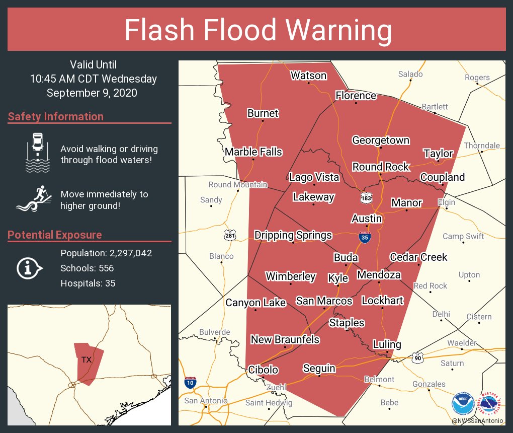
WEDNESDAY…. Cloudy with numerous rain showers and thunderstorms with an associated lightning threat. A 70%chance of rain; where rainfall occurs, it will average 0.25″ to 0.50″. High 85. Southeasterly wind 5 to 12 mph.
WEDNESDAY NIGHT…. Cloudy and turning a little cooler as a cold front passes by 10pm. Rain showers and thunderstorms with an associated lightning threat. Periods of heavier rain possible. A 90%chance of rain; where rainfall occurs, it will average 0.50″ to 1.00″. Low 64. East southeasterly wind shifting north northwesterly 8 to 15 mph.
THURSDAY…. Cloudy and unseasonably cool with numerous rain showers and a few thunderstorms early becoming more scattered in the afternoon. An associated lightning threat with any thunderstorm. A 90%chance of rain in the morning decreasing to 40%by afternoon; where rainfall occurs, it will average 0.25″ to 0.50″. High 74. Northerly wind 8 to 15 mph with some higher gusts.
THURSDAY NIGHT…. Mostly cloudy with scattered rain showers and a few thunderstorms with an associated lightning threat. A 40%chance of rain; where rainfall occurs, it will average 0.25″. Low 62. Northerly wind 8 to 15 mph.
FRIDAY…. Partly to mostly cloudy and not quite so cool with scattered rain showers and thunderstorms with an associated lightning threat. A 30%chance of rain; where rainfall occurs, it will average less than 0.25″. High 84. Northerly wind 5 to 10 mph early becoming light northerly by afternoon.
FRIDAY NIGHT…. Partly cloudy. Low 70. Light northerly wind.
SATURDAY…. Partly cloudy with scattered mainly afternoon rain showers and thunderstorms with an associated lightning threat. A 30%chance of rain; where rainfall occurs, it will average less than 0.25″. High 88. Light northerly wind.
SATURDAY NIGHT…. Partly cloudy. Low 71. Light wind.
SUNDAY…. Partly cloudy with scattered rain showers and thunderstorms by afternoon with an associated lightning threat. A 50%chance of rain; where rainfall occurs, it will average 0.25″. High 87. Light wind becoming northerly and increasing to 5 to 12 mph.
SUNDAY NIGHT…. Partly to mostly cloudy with scattered rain showers and thunderstorms with an associated lightning threat. A 30%chance of rain; where rainfall occurs, it will average 0.25″. Low 70. Northerly wind 5 to 10 mph.
MONDAY…. Mostly cloudy with scattered rain showers and thunderstorms with an associated lightning threat. A 50%chance of rain; where rainfall occurs, it will average 0.25″. High 87. North northeasterly wind 5 to 10 mph.
NATIONAL WEATHER SERVICE / 8 TO 14 DAY OUTLOOK
Valid Tuesday / 15 September 2020 through Monday / 21 September 2020…
Temperatures… Near to Slightly Below Average
Precipitation… Above Average
AUSTIN SUNSET/SUNRISE TIMES…..
Sunrise this morning (08 September)…………………………….. 7:12 am
Sunset this evening (08 September)………………………………. 7:45 pm
Sunrise tomorrow (09 September)…………………………………. 7:12 am
Sunset tomorrow (09 September)………………………………….. 7:43 pm