Special Briefing (605am CT-Sun/02Apr2017)

Austin / Travis County and South Central Texas Weather Update #4
Prepared by UT University/Incident Meteorologist Troy Kimmel
605am CT – Sunday / 02 April 2017

.. Authority / NWS Storm Prediction Center ..


URGENT – IMMEDIATE BROADCAST REQUESTED

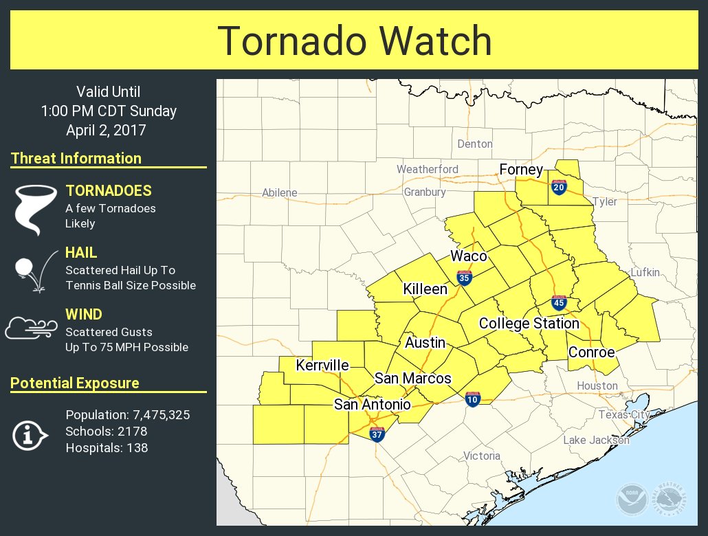
Tornado Watch Number 108
NWS Storm Prediction Center Norman OK
555 AM CDT Sun Apr 2 2017

The NWS Storm Prediction Center has issued a

* Tornado Watch for portions of 
  Parts of central and east Texas

* Effective this Sunday morning and afternoon from 555 AM until
  100 PM CDT.

* Primary threats include...
  A few tornadoes likely
  Scattered damaging winds and isolated significant gusts to 75
    mph possible
  Scattered large hail and isolated very large hail events to 2.5
    inches in diameter possible

SUMMARY...A large cluster of thunderstorms that has persisted
overnight west of San Antonio will likely begin to organize into
more of a bowing line with time, with an attendant increase in the
damaging wind risk.  Embedded circulations will also pose a tornado
risk.  Ahead of the line of storms, more isolated cells now forming
in the Houston to Austin corridor will shift northward with time,
and some could become supercells capable of producing a few
tornadoes later this morning.  Large hail will also be possible with
the stronger storms.

The tornado watch area is approximately along and 65 statute miles
north and south of a line from 55 miles west of Hondo TX to 40 miles
south southeast of Tyler TX. For a complete depiction of the watch
see the associated watch outline update (WOUS64 KWNS WOU8).

PRECAUTIONARY/PREPAREDNESS ACTIONS...

REMEMBER...A Tornado Watch means conditions are favorable for
tornadoes and severe thunderstorms in and close to the watch
area. Persons in these areas should be on the lookout for
threatening weather conditions and listen for later statements
and possible warnings.

&&

OTHER WATCH INFORMATION...CONTINUE...WW 107...

AVIATION...Tornadoes and a few severe thunderstorms with hail
surface and aloft to 2.5 inches. Extreme turbulence and surface wind
gusts to 65 knots. A few cumulonimbi with maximum tops to 550. Mean
storm motion vector 24035.

...Thompson


TXC021-029-031-053-055-091-149-187-209-259-287-299-453-491-021800-
/O.NEW.KEWX.TO.A.0108.170402T1100Z-170402T1800Z/

THE NATIONAL WEATHER SERVICE HAS ISSUED TORNADO WATCH 108 IN
EFFECT UNTIL 1 PM CDT THIS AFTERNOON FOR THE FOLLOWING AREAS

IN TEXAS THIS WATCH INCLUDES 14 COUNTIES

IN SOUTH CENTRAL TEXAS

BASTROP               BEXAR                 BLANCO               
BURNET                CALDWELL              COMAL                
FAYETTE               GUADALUPE             HAYS                 
KENDALL               LEE                   LLANO                
TRAVIS                WILLIAMSON            

THIS INCLUDES THE CITIES OF AUSTIN, BASTROP, BLANCO, BOERNE, 
BURNET, GEORGETOWN, GIDDINGS, LA GRANGE, LLANO, LOCKHART, 
NEW BRAUNFELS, SAN ANTONIO, SAN MARCOS, AND SEGUIN.

Special Briefing (955pm CT-Sat/01Apr2017)

Austin / Travis County and South Central Texas Weather Update #2
Prepared by UT University/Incident Meteorologist Troy Kimmel
955pm CT – Saturday / 01 April 2017

.. Marginal Severe Thunderstorm Risk Overnight Tonight ..
.. Severe Thunderstorm Risk Increases after 6 to 7am Tomorrow Morning and
Continues Through the Morning Hours for Areas Along and East of
the IH35 Corridor with a Large Hail Threat.. Damaging Straight Line Thunderstorm
Wind Threat.. and an Increasing Tornado Threat Particularly Through the
North.. Northeast and East of the IH35 Corridor and Austin Metro Area
..

As we prepare to retire for this Saturday night.. just a quick update. Although I
still think the severe thunderstorm risk will increase (perhaps rapidly) toward
daybreak, the latest high resolution guidance looks like it be a slower moving system
than I stated earlier today.

Be prepared to be dealing with a severe thunderstorm risk along and east of the IH35
corridor tomorrow around sunrise and thereafter through the morning with all
risks included.. particularly in areas north through northeast and east of the Austin area
proper. The short range high resolution data along with guidance from the NWS/Storm
Prediction Center is suggesting the possibility of widespread damaging straight line
thunderstorm winds along with a strong tornado threat in these areas east and northeast of
our local area. It may be too close for comfort even for parts of our local area.

Make sure you have several ways to obtain watch/advisory and warning information from the
National Weather Service.. these could be your NOAA All Hazards Weather Radio.. the
NWS/Austin-San Antonio website (http://www.weather.gov/ewx/).. the NWS/Austin-San Antonio
Twitter Site (https://twitter.com/NWSSanAntonio).. a weather app or the government alerts on
your cell phone.. as well as local radio news and local television stations. Most of all, please
discuss your weather safety plan with your family in case severe weather threatens your location
tomorrow morning.

Because the system may be moving a little slower, rainfall amounts of 1 to 2 inches are likely
in most areas.. particularly north through northeast and east of the Austin area.. will some isolated
heavier totals possible.

On this slightly slower progression.. it looks like the risk of severe weather will taper off in our
area by early afternoon.

Of course, weather forecasting is an imperfect science — I’ll continue to keep you informed of any
changes we see occurring.

tk

Updated 915am CT – Friday / 31 March 2017 .. Another Period of Stormy Weather Over the Weekend .. .. …

Read more