Troy Kimmel Weather

Forecasting Austin and South Central Texas Weather Since 1984

TK’s Special Briefing….

Austin / Travis County and South Central Texas Weather Update #1
Prepared by Incident Meteorologist Troy Kimmel (www.troykimmelweather.com)
730am CT – Monday / 12 May 2014

…. Strong Cold Front Due Late Tonight ….
…. Rain Showers and Thunderstorms Expected.. Some Heavy and Possibly Severe ….
…. Flash Flood Watch in Effect for the IH35 Corridor 6pm Tonight Until Noon Tomorrow ….

. Weather Discussion ..
Early this Monday morning, a strong cold front is oriented from eastern Kansas south
southwestward into western Oklahoma and far west Texas /south of Lubbock/ then west
northwestward into eastern/northern New Mexico. In the upper levels of the atmosphere..
a strong/vigorous eastward moving upper level low pressure disturbance and trough
extends south southwestward from western Colorado into northwestern Mexico and the
Baja Peninsula.

As the cold front moves southeastward into the area by a little after midnight tonight and
the upper air disturbance approaches the area from the west..  atmospheric lift and instability
will be maximized. As a result, I expect a round of thunderstorms by later today  into tonight.
There will be a “slight” risk of severe thunderstorms along with the possibility of periods of
heavy rain.

The upper level disturbance out west will lag behind the cold front; as a result, rain showers
and even some thunderstorms will continue to “overrun” the much cooler surface air for about
12 to 18 hours (through the day tomorrow into tomorrow night) following the cold frontal passage.

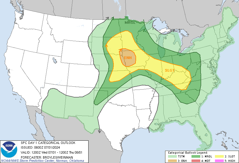
The NWS Storm Prediction Center has placed most of the local area is a “SLIGHT”
risk area this afternoon into tonight for severe thunderstorms (see map below) with the primary
hazards locally being larger hail and damaging straight line thunderstorms wind.


For the entire day one outlook and text discussion, see this web page…
http://www.spc.noaa.gov/products/outlook/day1otlk.html

Forecast rainfall amounts late today into tonight and Tuesday are generally expected to be in the
one to two inch range with isolated heavier totals to 3 or more inches possible. Current flash flood
guidance for Travis County… very rough estimates of what it would take to initiate flash flooding
in a given period… is 3.1 inches in a one hour period, 4.0 inches in a three hour period and 5.2
inches for a six hour period. Flash or urban/small stream flooding is going to be a risk in areas
where heavier thunderstorms occur. As well, flash flooding is a possibility, as indicated by the
NWS’ flash flood watch. Remember the NWS slogan, “turn around, don’t drown.”

Bottom line.. let’s be weather aware again today into tonight and Tuesday… first thing this morning,
please check your NOAA/NWS All Hazards Weather Radios to make sure that the radio is in
the “stand by” mode so that they’ll automatically alarm if and when the NWS Storm Prediction
Center and/or NWS Austin-San Antonio issues watches and warnings across the area today into
early tonight.

I’ll continue to keep you updated.

Troy
TK’s Special Briefing….

Austin / Travis County and South Central Texas Weather Update #3  – FINAL UPDATE
Prepared by Incident Meteorologist Troy Kimmel (www.troykimmelweather.com)
530pm CT – Friday / 9 May 2014

…. Severe Weather Risk Diminishes  ….
…. Looking Ahead into Early Next Week …. Storms with Another Strong Cold Front ….

At 520pm CT.. Doppler weather radar indicates a few rain showers from southeastern
parts of the Austin metro area and Travis County into counties to the south and east. The
activity is moving away from the Austin area and the IH35 corridor.

Even though isolated rain showers and thunderstorms could develop over the next few
hours.. most of them will be to out south and southeast and I do not anticipate any big
problems. The weekend looks quiet for our upcoming weekend.

…. Looking Ahead ….

As we go into the weekend, I want to let you know of a storm system and rather strong
cold front due to pass overhead by Monday night into Tuesday. Current guidance
suggests that rain showers and thunderstorms will increase over the area Monday through
Monday night and into Tuesday with NWS guidance suggesting up to 3 to 4 inches of rain
in some areas of south central Texas. It’s too early to call it, though (especially with
guidance suggesting a couple of inches of rain in some areas yesterday into today.. how’d
that work out????).. the bottom line,  I’ll continue to monitor the weather situation for you.

This is my final update on this Friday weather event.

Have a great weekend,
Troy

Austin / Travis County and South Central Texas Weather Update #2
Prepared by Incident Meteorologist Troy Kimmel (www.troykimmelweather.com)
1255pm CT – Friday / 9 May 2014

…. Attention Southern Hays County ….

…. Strong Thunderstorms to our Southwest ….
…. Severe Thunderstorm Watch Remains in Effect until 7pm ….

At 1255pm.. strong thunderstorms extend from south of Johnson City and Blanco southward
to the San Antonio metro area. These thunderstorms are generally moving eastward as a dry
line over the Texas hill country and an associated upper air disturbance presses eastward and
creates atmospheric lift in advance of it.

While it appears that the majority of this activity will stay just south of the Austin area in areas
from Kyle and Buda southward to San Marcos and New Braunfels.. we must carefully monitor
for additional development in the Austin area and along the IH35 corridor as the disturbance
and the dry line out west continue to move eastward.

Remember that the primary threat today is larger hail and damaging straight line
thunderstorm winds. The tornado threat today is very slim.

Remember, too, that associated frequent cloud-to-ground lightning is very deadly and dangerous.

I’ll continue to monitor…. tk

Austin / Travis County and South Central Texas Weather Update #1
Prepared by Incident Meteorologist Troy Kimmel (www.troykimmelweather.com)
745am CT – Friday / 9 May 2014

…. Another “Slight” Risk of Severe Thunderstorms Today into Early Tonight ….

. Weather Discussion ..
Early this Friday morning, a surface low pressure area is over central Oklahoma with a
dry line.. separating continental tropical dry air to the west from moist tropical air to
the east.. extending south southwestward from the low into far southwest Texas around
Del Rio.  In the upper levels of the atmosphere.. a strong eastward moving upper level
low pressure disturbance – the last one part as part of the upper air disturbance that
moved across the area yesterday – is located over Mexico south of El Paso.

As that upper air disturbance moves eastward across south central Texas today.. in
association with intense daytime hearing and the dry line moving eastward.. atmospheric
lift and instability will be maximized. As a result, I now expect another round of thunderstorms
this afternoon into this evening – with perhaps a little greater risk of severe weather and even
a little more coverage than yesterday.

Once the disturbance moves northeast of the area.. by the mid evening hours tonight..
the threat of severe thunderstorms will end.

The NWS Storm Prediction Center has placed most of the local area is a “SLIGHT”
risk area today into tonight for severe thunderstorms (see map below) with the primary
hazards locally being larger hail and damaging straight line thunderstorms wind. An
isolated tornado is possible as well.

For the entire day one outlook and text discussion, see this web page…
http://www.spc.noaa.gov/products/outlook/day1otlk.html

Forecast rainfall amounts today into tonight are generally expected to be 1/2 inch or less.. but
isolated heavier totals to 1 or more inches are certainly possible. Current flash flood guidance
for Travis County… very rough estimates of what it would take to initiate flash flooding…
is 2.9 inches in a one hour period, 3.8 inches in a three hour period and 5.0 inches for a six hour
period. I think that flash or urban/small stream flooding, given the on going drought conditions, is
going to be a very small risk. Remember that if everyone drives intelligently and remembers the
NWS slogan, “turn around, don’t drown,” this will not be a big issue
.

Bottom line.. let’s remain weather aware again today… following the few warnings issued late
yesterday, please recheck your NOAA/NWS All Hazards Weather Radios to make sure that
they are in “stand by” mode so that they’ll automatically alarm if and when the NWS Storm
Prediction Center and/or NWS Austin-San Antonio issues watches and warnings across the area
today into early tonight.

I’ll continue to keep you updated.

Troy

TK’s Special Briefing….

Austin / Travis County and South Central Texas Weather Update #4 Prepared by Incident Meteorologist Troy Kimmel (www.troykimmelweather.com) 945pm CT …

Read more