Audio Weather Webcast
(Includes My Complete Forecast Reasoning)
Updated Wednesday / 09 September 2020 ….
Contact me:
[email protected]
[email protected]
On Twitter, follow me and
activate notifications for my tweets…
@troykimmelwx
—-
AUSTIN / UNIVERSITY OF TEXAS
WEATHER HAZARDS THROUGH 12 MIDNIGHT TONIGHT…
… Lightning Threat with Any Thunderstorm Today Through Tonight …
—-
AUSTIN / UNIVERSITY OF TEXAS WEATHER
SEVEN DAY WEATHER HEADLINES
AND MY 7 DAY FORECAST CONFIDENCE …
(1) A very complicated weather pattern has set up for the next few days as abundant low level moisture from the Gulf of Mexico moves northward across the area ahead of a deepening trough, or line, of upper level low pressure in the Rockies and intermountain west. A strong cold front, with a 20 to 30 degree drop in temperatures, is moving slowly eastward this morning and extends south southwestward from western Oklahoma and north Texas into the Rio Grande plains east and south of Del Rio.
(2) As our atmosphere continues excessively moist and unstable and the cold front moves east southeastward, scattered to numerous rain showers and thunderstorms will continue locally with the cold front pulling very sluggishly eastward through the IH35 corridor late tonight. Even as a little cooler air takes hold, an overrunning pattern, with scattered rain showers and a few thunderstorms will prevail for tomorrow into tomorrow night.
(3) After a brief break in rain chances Friday through Saturday into Saturday night, another cold front and upper air disturbance will move into the area by Sunday into the first part of next week with increased rain and thunderstorm chances again.
MY FORECAST CONFIDENCE OVER THE NEXT SEVEN DAYS…
Today through Saturday night..
High confidence
Saturday Night through Tuesday..
Moderate to high confidence
—-
Troy’s Weather Forecast for Austin and South Central Texas
Updated Wednesday / 09 September 2020
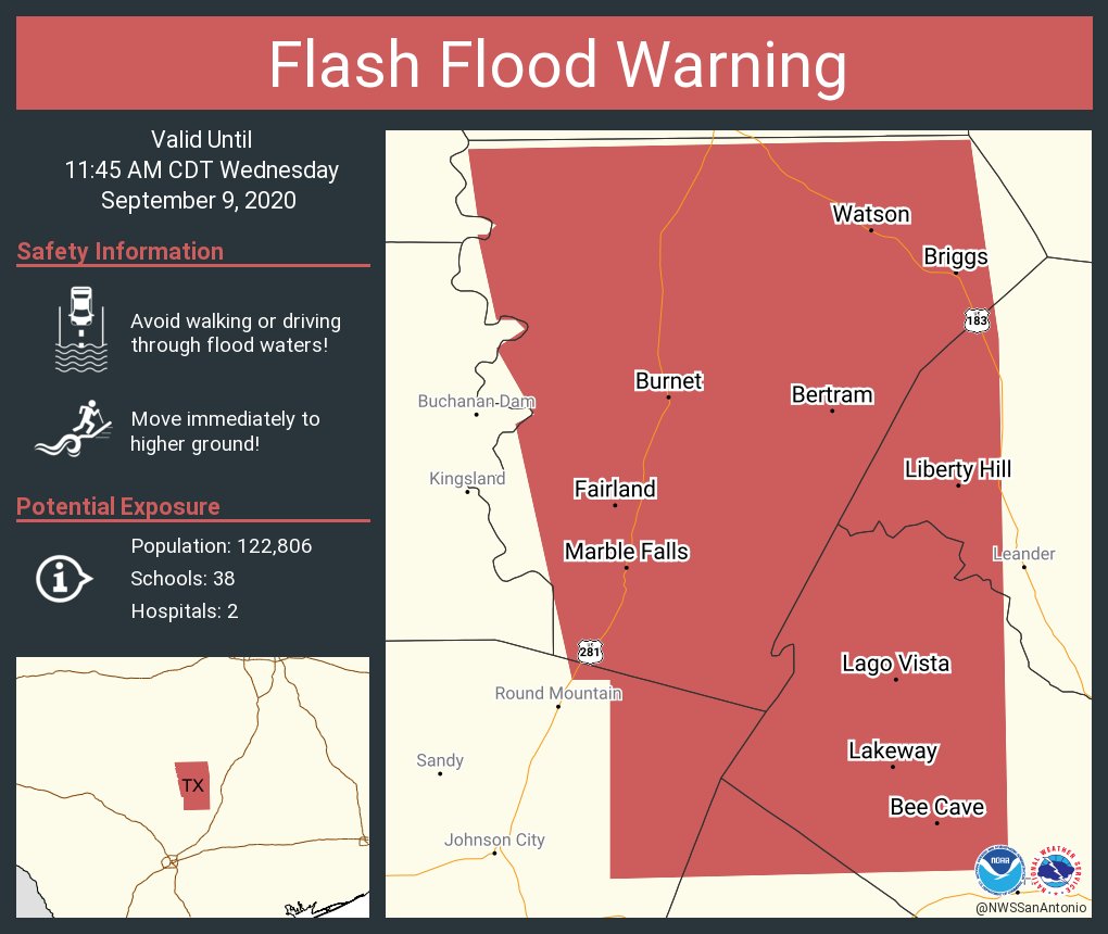
… NWS / Austin San Antonio has issued a FLASH FLOOD WATCH valid into Thursday for the Austin metro area and the IH35 corridor …
TODAY…. Cloudy with numerous rain showers and thunderstorms with an associated lightning threat. A 70%chance of rain; where rainfall occurs, it will average 0.50″ to 1.00″. High 84. South southeasterly wind 5 to 12 mph.
TONIGHT…. Cloudy and turning a little cooler as a cold front passes by midnight. Rain showers and thunderstorms with an associated lightning threat. Periods of heavier rain possible. A 90%chance of rain; where rainfall occurs, it will average another 0.50″ to 1.00″. Low 64. East southeasterly wind shifting north northwesterly 5 to 12 mph.
THURSDAY…. Cloudy with scattered rain showers and a few thunderstorms early becoming more scattered as skies become partly cloudy in the afternoon. An associated lightning threat with any thunderstorm. A 60%chance of rain in the morning decreasing to 30%by afternoon; where rainfall occurs, it will average 0.25″ to 0.50″. High 81. Northerly wind 8 to 15 mph.
THURSDAY NIGHT…. Partly cloudy with widely scattered rain showers. A 20%chance of rain; where rainfall occurs, it will average 0.25″. Low 64. Northerly wind 5 to 12 mph.
FRIDAY…. Partly cloudy with widely scattered rain showers and thunderstorms with an associated lightning threat. A 20%chance of rain; where rainfall occurs, it will average less than 0.25″. High 88. Northerly wind 5 to 10 mph.
FRIDAY NIGHT…. Partly cloudy. Low 68. Light northerly wind.
SATURDAY…. Partly cloudy with widely scattered afternoon rain showers and thunderstorms with an associated lightning threat. A 20%chance of rain; where rainfall occurs, it will average less than 0.25″. High 89. Light northerly wind.
SATURDAY NIGHT…. Partly cloudy. Low 72. Light wind.
SUNDAY…. Partly cloudy with scattered rain showers and thunderstorms by afternoon with an associated lightning threat. A 50%chance of rain; where rainfall occurs, it will average 0.25″. High 90. Light wind.
SUNDAY NIGHT…. Partly to mostly cloudy with scattered rain showers and thunderstorms with an associated lightning threat. A 30%chance of rain; where rainfall occurs, it will average 0.25″. Low 71. Northerly wind 5 to 10 mph.
MONDAY…. Mostly cloudy with scattered rain showers and thunderstorms with an associated lightning threat. A 50%chance of rain; where rainfall occurs, it will average 0.25″. High 87. North northeasterly wind 5 to 10 mph.
MONDAY NIGHT…. Mostly cloudy with scattered rain showers and thunderstorms with an associated lightning threat. A 30%chance of rain; where rainfall occurs, it will average 0.25″. Low 71. Northerly wind 5 to 10 mph.
TUESDAY…. Mostly cloudy with scattered rain showers and thunderstorms with an associated lightning threat. A 50%chance of rain; where rainfall occurs, it will average 0.25″. High 87. North northeasterly wind 5 to 10 mph.
NATIONAL WEATHER SERVICE / 8 TO 14 DAY OUTLOOK
Valid Wednesday / 16 September 2020 through Tuesday / 22 September 2020…
Temperatures… Near to Slightly Below Average
Precipitation… Above Average
AUSTIN SUNSET/SUNRISE TIMES…..
Sunrise this morning (09 September)…………………………….. 7:12 am
Sunset this evening (09 September)………………………………. 7:43 pm
Sunrise tomorrow (10 September)…………………………………. 7:13 am
Sunset tomorrow (10 September)………………………………….. 7:42pm