Troy Kimmel Weather

Forecasting Austin and South Central Texas Weather Since 1984

…. FLASH FLOOD WATCH CONTINUES …. (910pm CT-Fri/20Mar2015)

Austin / Travis County and South Central Texas Weather Update #5
Prepared by UT University/Incident Meteorologist Troy Kimmel
910pm CT – Friday / 20 March 2015


. NWS/Flash Flood Watch Continues Until 7pm Saturday ..

. NWS/Weather Prediction Center Has Issued a Heavy Rainfall
Mesoscale Discussion for Areas Primarily South/Southeast of Austin…
(Link: http://www.wpc.ncep.noaa.gov/metwatch/metwatch_mpd_multi.php?md=0015&yr=2015 )
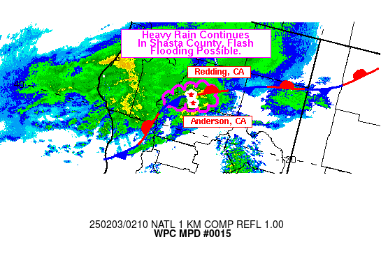
Graphic for MPD #0015

MESOSCALE PRECIPITATION DISCUSSION 0015
NWS WEATHER PREDICTION CENTER COLLEGE PARK MD
954 PM EDT FRI MAR 20 2015
 
AREAS AFFECTED...SOUTH TEXAS 
 
CONCERNING...HEAVY RAINFALL...FLASH FLOODING POSSIBLE 
 
VALID 210150Z - 210750Z
 
SUMMARY...INCREASINGLY ORGANIZED AND SLOW-MOVING SHOWERS AND
THUNDERSTORMS ARE ANTICIPATED OVERNIGHT. THE SLOW MOVEMENT AND
HEAVIER RAINFALL RATES WILL CONTRIBUTE TO A FLASH FLOOD THREAT.

DISCUSSION...THE LARGER SCALE PATTERN FEATURES A DEEP FETCH OF MID
AND HIGH LEVEL SUBTROPICAL MOISTURE CROSSING CENTRAL AND NORTHEAST
MEXICO AND LIFTING ACROSS THE LOWER RIO GRANDE VALLEY OF TEXAS.
THIS IS ALL OUT AHEAD OF AN UPPER LOW FOCUSED OVER THE BAJA
PENINSULA. MEANWHILE...A COLD FRONT IS GRADUALLY SETTLING SOUTH
ACROSS SOUTHEAST TEXAS. THE FEED OF MOISTURE ALONG WITH EMBEDDED
SHORTWAVE ENERGY IS INTERACTING WITH THE FRONT AND ALREADY
PRODUCING A BROKEN AXIS OF SHOWERS AND THUNDERSTORMS.

OVER THE NEXT FEW HOURS...THERE SHOULD BE A GRADUAL INCREASE IN
CONVECTIVE ORGANIZATION AS MID LEVEL VORT ENERGY OVER MEXICO LIFTS
NORTHEAST ACROSS THE LOWER RIO GRANDE VALLEY. THIS COUPLED WITH
H25 RRQ JET DYNAMICS AND LOW LEVEL SPEED CONVERGENCE IN VICINITY
THE AFOREMENTIONED FRONT WILL SUPPORT THE UPTICK IN CONVECTION.

PWATS ARE QUITE HIGH...RUNNING AOA 1.75 INCHES OVER MUCH OF SOUTH
TEXAS...AND THE LATEST GLOBAL MODELS SUGGEST ACTUALLY AN
ADDITIONAL INCREASE IN PWATS OVERNIGHT...LOCALLY APPROACHING 2
INCHES. THE 18Z NAM...12Z ARW AND 12Z NMMB ALL REFLECT SIGNALS FOR
HEAVY RAINFALL...ESPECIALLY AFTER MIDNIGHT...WITH SEVERAL INCHES
OF RAIN POSSIBLE LOCALLY. GIVEN THE ANTICIPATED SLOW MOVEMENT AND
HIGH PWAT ENVIRONMENT...HEAVY TOTALS APPEAR LIKELY...AND SO THERE
SHOULD BE A THREAT FOR FLASH FLOODING. WILL CONTINUE TO MONITOR.

ORRISON

ATTN...WFO...BRO...CRP...EWX...HGX...

ATTN...RFC...WGRFC...

… Flash Flood Watch in Effect Until 7pm Saturday … (Update #3)

Austin / Travis County and South Central Texas Weather Update #3
Prepared by UT University/Incident Meteorologist Troy Kimmel
125pm CT – Friday / 20 March 2015


. NWS/Flash Flood Watch Effective For All of our Area at 1pm ….

. Latest NWS/West Gulf River Forecast Center Quantitative Precipitation
Forecast (QPF) Rainfall Amounts between now and 7am Sunday still suggests 3 to 4 inches locally…


NWS WATCHES / ADVISORIES / WARNINGS:
NWS /  Flash Flood Watch (Valid from 100pm Fri/20Mar2015 until 700pm Sat/21Mar2015)
Counties Included.. Williamson.. Hays and Travis (Including Austin Metro Area and IH 35
Corridor) as well as all adjacent counties
Rainfall to 3 to 4 inches or more… NWS/Austin-San Antonio forecasting isolated totals to 6 to 8 inches.

OBSERVATIONS AND MY LATEST THOUGHTS:
A weak cold front is progressing southeastward across the Austin metro area at 1pm today with
the front just passing Camp Mabry where their temperature has fallen 7 or 8 degrees in the last
hour. Temperatures ahead of the front are in the low 70s with temperatures falling into the 50s to
low 60s immediately behind the front. This front is expected to become the focus for rain shower and
thunderstorm activity in the next few hours with the approach of the upper level low over northwestern
Mexico.

NWS Doppler weather radar shows eastward moving rain shower and thunderstorm activity becoming
more widespread over the northwestern Texas hill country. Rain showers are also developing along
the cold front over our metro area as well as to the south of the area.. those precipitation elements are
moving northward.

Widespread rain showers and thunderstorms are expected by later this afternoon and continuing
through tonight and through the day Saturday with generalized 3 to 4 inch rainfall totals with isolated
heavier totals possible as noted by NWS/Austin-San Antonio.

No flooding is indicated anywhere in the area as of 1pm today.

Given the ongoing threat of heavier rainfall as well as the possibility of flooding tonight into Saturday,
all interests throughout south central Texas should remain weather aware and listen for the latest
information from the NWS/Austin-San Antonio as well as local emergency management officials.

Have your NOAA/NWS All Hazards Weather Radios reset and ready to alarm in case the
NWS/Austin-San Antonio issues additional advisories and warnings over the next 48 hours.

The LCRA Hydromet is a great way to keep informed of ground truth precipitation amounts…
http://hydromet.lcra.org/full.aspx

The City of Austin Watershed Protection website… www.atxfloods.com … is a great way to keep
track of flooded low water crossings throughout the area.

I’ll continue to monitor the weather situation..

tk