ALL / Austin, Travis County and South Central Texas Weather Update #1
Prepared by UT University/Incident Meteorologist Troy Kimmel
950am CT – Monday / 02 March 2020


… Slight Severe Thunderstorm Risk / Heavier Rainfall Risk Late Tomorrow through Tomorrow Night …
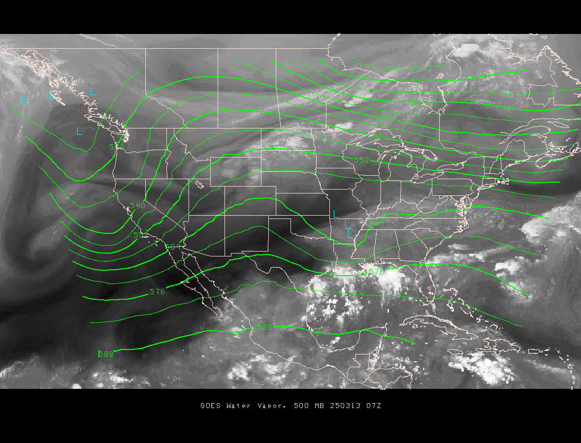
As we start the new week, at the surface, a cold front is pushing south southeastward from northwestern Arkansas and southeastern Oklahoma across the Red River into the Texas South Plains around Lubbock then continuing into New Mexico. In the upper levels of the atmosphere, a broad and dynamic trough extends southwestward from the Rockies into the eastern Pacific Ocean southwest of San Diego, CA where we find a strong upper level disturbance embedded.
Over the next 24 hours, the surface front will weaken as it moves southward further into Texas as the strong trough and upper air low pressure disturbance moves eastward into northern Mexico. As this occurs, we will find our atmosphere becoming more moist and increasingly unstable. By tomorrow, the front will drift southward through our area as strong dynamics, associated with the upper air disturbance, spread across our area later in the day with increased atmospheric lift. As a result, we’ll see rain shower and thunderstorm activity increase over our area through the day tomorrow. The best rain and thunderstorm chances will come late tomorrow afternoon through tomorrow night into the predawn hours on Wednesday. The entire system should pass east of the area by midday into afternoon Wednesday with rain chances decreasing from west to east over our area.
The exact timing of the cold front and the passage of the upper air trough/upper level disturbance will be critical in determining exact hour by hour forecast weather. However, the two things I think we must be watching is the “slight” possibility of severe thunderstorms (as forecast by the NWS/Storm Prediction Center) as well as the prospect for some heavier rainfall locally.
First, the severe weather threat. The NWS/Storm Prediction Center outlook suggests, and I agree, that the best atmospheric lift will not move across our area until tomorrow night into Wednesday morning after the surface cold front has passed southward through the area. If this ends up being the case (with elevated thunderstorms over the top of the cooler surface based air), the main risks would be some larger hail along with the possibility of stronger straight line thunderstorm winds. This would occur, based on the latest guidance, in the 11 pm to 7am time frame tomorrow night into Wednesday morning. While not a criteria for severe
thunderstorms, dangerous lightning would also be a threat, of course, with any thunderstorms.
Secondly, based on the latest model guidance and the guidance prepared by the NWS/Weather Prediction Center, we could potentially see 1 to 2 inches of rain locally with isolated heavier totals to 4 inches especially north of Austin. Given the rather dry conditions, especially east, southeast and south of Austin, I am not too worried about any widespread problems other than potential urban/small stream flooding but we need to watch the possibility of those isolated heavier totals since that could possibly result in the NWS issuance of flash flood warnings.
I’ll continue to monitor..
tk
Audio Weather Webcast
(Includes My Complete Forecast Reasoning)
Updated Monday / 02 March 2020 ….
Contact me:
[email protected]
[email protected]
On Twitter, follow me and
activate notifications for my tweets…
@troykimmelwx
—-
AUSTIN / UNIVERSITY OF TEXAS
WEATHER HAZARDS THROUGH 12 MIDNIGHT TONIGHT…
.. No Hazards Expected ..
—-
AUSTIN / UNIVERSITY OF TEXAS WEATHER
SEVEN DAY WEATHER HEADLINES…
(1) Our next upper level low pressure area and surface cold front approaches from the west and north over the next 24 hours. We’ll see a chance of rain by early tomorrow with thunderstorm chances increasing thereafter into Tuesday as the cold front moves south of the area and the upper air low pressure disturbances moves slowly west to east over the area. Some stronger thunderstorms, with a risk of hail and strong straight line thunderstorm winds, are possible along with average rainfall of 1 to 2 inches with isolated totals to 4 inches.
(2) A drier and a little cooler weather pattern returns by Wednesday night through the end of the week into the weekend.
—-
Troy’s Weather Forecast for Austin and South Central Texas
Updated Monday / 02 March 2020
TODAY…. Patchy morning fog otherwise mostly cloudy. High 79. Southerly wind 5 to 12 mph.
TONIGHT…. Cloudy with a few sprinkles developing after midnight. A 20% chance of rain; where rainfall occurs, it will average trace amounts. Low 62. South southeasterly wind 4 to 8 mph becoming light late.
TUESDAY…. Cloudy with scattered to numerous rain showers developing as a cold front passes by early afternoon. Thunderstorms developing by afternoon with an associated lightning risk as well as a hail risk. A 30% chance of morning rain with rain chances increasing to 70% by afternoon; where rainfall occurs, it will average .50 to 1.00″. High 71. Light southerly wind becoming north northeasterly 5 to 12 mph in the morning.
TUESDAY NIGHT…. Cloudy with rain showers and a few thunderstorms with an associated lightning risk as well as a hail risk. A 90% chance of rain; where rainfall occurs, it will average an additional .50 to 1.00″. Low 56. Northeasterly wind 5 to 10 mph becoming north northwesterly 8 to 15 mph after midnight.
WEDNESDAY…. Cloudy with scattered to numerous rain showers and an isolated thunderstorm with an associated lightning risk through midday with rain chances decreasing by afternoon. Decreasing clouds mid and late afternoon. A 60% chance of rain; where rainfall occurs, it will average an additional .25″. High 64. North northwesterly wind 8 to 15 mph.
WEDNESDAY NIGHT…. Partly cloudy and cooler. Low 46. North northwesterly wind 5 to 12 mph.
THURSDAY…. Sunshine. High 69. Northerly wind 5 to 8 mph.
THURSDAY NIGHT…. Clear. Low 46. Light northeasterly wind.
FRIDAY…. Sunshine. High 71. East northeasterly wind 4 to 8 mph.
FRIDAY NIGHT…. Mostly clear. Low 45. Light easterly wind.
SATURDAY…. Mostly sunny. High 72. Southeasterly wind 5 to 10 mph.
SATURDAY NIGHT…. Mostly clear. Low 46. Light southeasterly wind.
SUNDAY…. Mostly sunny. High 73. Southeasterly wind 4 to 8 mph.
NATIONAL WEATHER SERVICE / 8 TO 14 DAY OUTLOOK
Valid Monday / 09 March 2020 through Sunday / 15 March 2020…
Temperatures… Above Average
Precipitation… Slightly Above Average
AUSTIN SUNSET/SUNRISE TIMES…..
Sunrise this morning (02 March)………………………………….. 6:56 am
Sunset this evening (02 March)……………………………………. 6:31 pm
Sunrise tomorrow (03 March)………………………………………. 6:55 am
Sunset tomorrow (03 March)……………………………………….. 6:31 pm