ALL / Austin, Travis County and South Central Texas Weather Update #2
Prepared by UT University/Incident Response Meteorologist Troy Kimmel
1050am CT – Friday / 09 September 2020
My Observations/Thoughts…
As I noted earlier today, given latest rainfall amounts, I am not concerned locally on the IH35 corridor at the current time with most ground truth rainfall in the immediate area generally less than an inch so far.. see map below..
My greatest immediate concern is for hill country well west/northwest of the IH35 corridor.
HOWEVER, please remember that there is more rainfall in the forecast with another couple of inches of rain possible; a Flash Flood WATCH remains in effect through tomorrow for the IH35 corridor counties and westward.. please remember, “Turn Around, Don’t Drown.”
Here are LCRA Hydromet rainfall amounts as of 1045am (since midnight)…

I’m continuing to monitor..
tk
… Authority / NWS Austin-San Antonio …
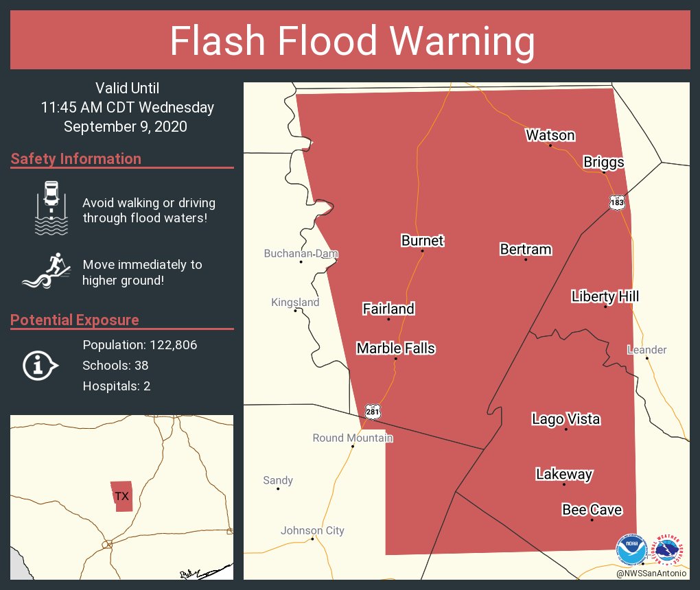
BULLETIN - EAS ACTIVATION REQUESTED
Flash Flood Warning
National Weather Service Austin/San Antonio TX
1041 AM CDT Wed Sep 9 2020

The National Weather Service in Austin/San Antonio has extended the

* Flash Flood Warning for...
  Northeastern Blanco County in south central Texas...
  Burnet County in south central Texas...
  Northwestern Hays County in south central Texas...
  Northwestern Travis County in south central Texas...
  Northwestern Williamson County in south central Texas...

* Until 1145 AM CDT.

* At 1041 AM CDT, Doppler radar indicated thunderstorms producing
  heavy rain across the warned area. Between 1 and 2 inches of rain
  have fallen. Flash flooding is ongoing or expected to begin
  shortly.

  HAZARD...Life threatening flash flooding. Thunderstorms
           producing flash flooding.

  SOURCE...Doppler radar.

  IMPACT...Life threatening flash flooding of creeks and streams,
           urban areas, highways, streets and underpasses.

* Some locations that will experience flash flooding include...
  Austin, Cedar Park, Burnet, Marble Falls, Bertram, Round Mountain,
  Leander, Lakeway, Lago Vista, Bee Cave, Granite Shoals, Horseshoe
  Bay, Hudson Bend, The Hills, Meadowlakes, Liberty Hill, Oatmeal,
  Smithwick, Shady Grove and Spicewood.
Reminders…
I encourage everyone to be weather aware. Know, in advance, the difference between a
NWS issued WATCH, ADVISORY and WARNING.