Austin / Travis County and South Central Texas Weather Update #3
Prepared by UT University/Incident Meteorologist Troy Kimmel
715am CT – Thursday / 23 April 2015
….”Slight” Risk of Severe Thunderstorms For Our Western Areas Today..
Continued Areawide “Slight” Risk Tomorrow ….
With our return south southeasterly surface wind, we’ve seen a pronounced
low level moisture return across the area. We’re also seeing a moderate westerly
upper level winds are bringing some mid and high level Pacific moisture.. in the
form of mid and high clouds.. to our local area.
A series of weak cold fronts will approach the area from the north over the coming
days, but I don’t see the fronts making their way this far south. At the same time,
through the end of the week, we’re seeing the influence of passing upper air
disturbances a counter clockwise rotating low pressure area system located
over southern California.. southern Nevada and western Arizona. As a result of
increased upward motion in the atmosphere along with the more moist and unstable
air mass in place will bring us continued increased clouds as well as rain and
thunderstorms chances through the remainder of the week.
Yesterday, the thunderstorms were concentrated in areas to our distant south and
north. Today, I expect severe thunderstorms to be mainly west of the IH35
corridor.. but isolated strong thunderstorms could occur anywhere.
Tomorrow (Friday), the threat will be areawide.
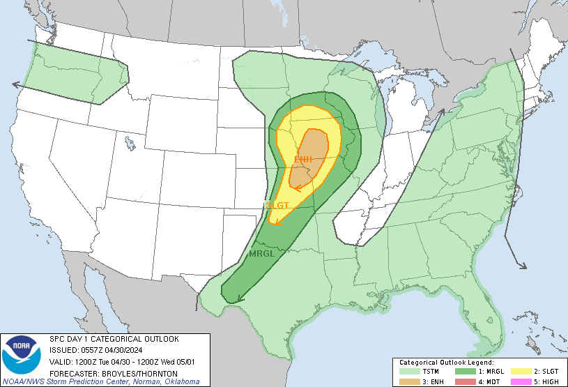
The latest NWS/Storm Prediction Center guidance suggests the possibility of
stronger.. potentially severe.. thunderstorms for parts of Texas (including parts
of our local area) for today through tomorrow.
Here’s todays SPC outlook….
In addition, the latest NWS rainfall forecast guidance shows the potential of 3/4
to 1 1/2 inch of rain between now and Saturday.
I’m continuing to monitor.. tk