An additional way to get the latest on the developing weather situation,
(watches and warnings for the Austin area IH35 corridor)
follow Troy on Twitter… @troykimmelwx
—
EVENT SUMMARY:
…. Round of Strong to Severe Thunderstorms Moving Through ….
…. Severe Thunderstorm WATCH until 2am for the IH35 Corridor ….
…. General Risk Period: through 2am ….
… Severe Thunderstorm Warning Issued ….

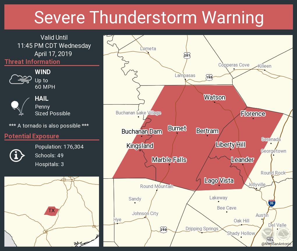
BULLETIN - IMMEDIATE BROADCAST REQUESTED
Severe Thunderstorm Warning
National Weather Service Austin/San Antonio TX
1051 PM CDT Wed Apr 17 2019

The National Weather Service in Austin San Antonio has issued a

* Severe Thunderstorm Warning for...
  Western Williamson County in south central Texas...
  Northwestern Travis County in south central Texas...
  Southeastern Llano County in south central Texas...
  Burnet County in south central Texas...

* Until 1145 PM CDT.

* At 1050 PM CDT, severe thunderstorms were located along a line
  extending from near Lampasas to near Horseshoe Bay, moving east at
  40 mph.

  HAZARD...60 mph wind gusts and penny size hail.

  SOURCE...Radar indicated.

  IMPACT...Expect damage to roofs, siding, and trees.

* Locations impacted include...
  Cedar Park, Georgetown, Burnet, Marble Falls, Kingsland, Bertram,
  Buchanan Dam, Leander, Lago Vista, Granite Shoals, Horseshoe Bay,
  Meadowlakes, Liberty Hill, Florence, Highland Haven, Inks Lake
  State Park, Spicewood, Watson, Lake Victor and Joppa.

PRECAUTIONARY/PREPAREDNESS ACTIONS...

For your protection move to an interior room on the lowest floor of a
building.

Intense thunderstorm lines can produce brief tornadoes and widespread
significant wind damage. Although a tornado is not immediately
likely, it is best to move to an interior room on the lowest floor of
a building. These storms may cause serious injury and significant
property damage.
An additional way to get the latest on the developing weather situation,
(watches and warnings for the Austin area IH35 corridor)
follow Troy on Twitter… @troykimmelwx
—
Austin / Travis County and South Central Texas Weather Update #5
Prepared by UT University/Incident Meteorologist Troy Kimmel
725pm CT – Wednesday / 17 April 2019
EVENT SUMMARY:
…. Round of Strong to Severe Thunderstorms Likely in the Overnight Hours ….
…. NWS/Storm Prediction Center Continues Enhanced Severe Weather Risk for Area ….
…. Main Risks: Larger Hail and Damaging Thunderstorm Winds
w/Tornado Risk Mainly N-NE of Austin Metro Area ….
…. General Risk Period (Revised): 11pm Tonight to 2am Tomorrow Morning ….
A quick update.. a SEVERE THUNDERSTORM WATCH is now in effect until 200am for
the IH35 corridor counties and westward..

Keeping you informed..
TK
—-
An additional way to get the latest on the developing weather situation,
(watches and warnings for the Austin area IH35 corridor)
follow Troy on Twitter… @troykimmelwx
—
Austin / Travis County and South Central Texas Weather Update #4
Prepared by UT University/Incident Meteorologist Troy Kimmel
705pm CT – Wednesday / 17 April 2019
EVENT SUMMARY:
…. Round of Strong to Severe Thunderstorms Likely in the Overnight Hours ….
…. NWS/Storm Prediction Center Continues Enhanced Severe Weather Risk for Area ….
…. Main Risks: Larger Hail and Damaging Thunderstorm Winds
w/Tornado Risk Mainly N-NE of Austin Metro Area ….
…. General Risk Period (Revised): 11pm Tonight to 2am Tomorrow Morning ….
There’s no change in my thoughts as we get into early evening; however the
NWS/Storm Prediction Center has just issued a mesoscale discussion indicating that
a severe weather watch is likely (a 95% chance) for areas west of the IH35
corridor “soon.”

I’ll continue to keep you informed.
TK